


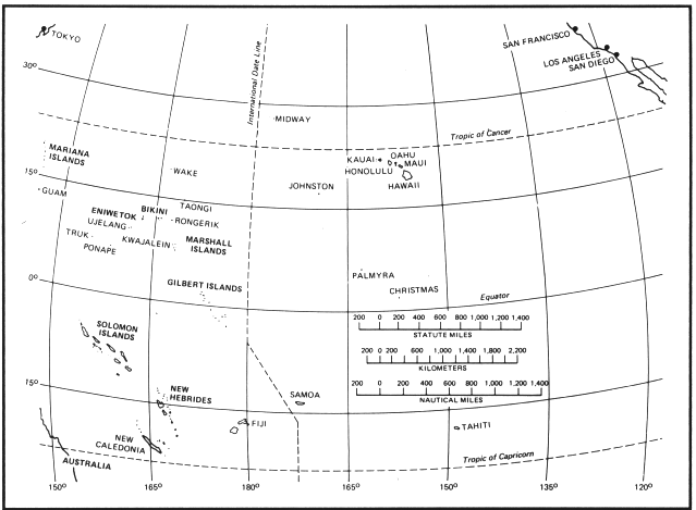
The possibilities for conducting atmospheric nuclear tests in the continental United States are limited due to the problems of downwind fallout contamination. Following World War II interest immediately developed in finding a remote a test site far from significant populations. The vast expanse and equitable climate of the Pacific Ocean immediately suggested itself, and the Trust Territory of the Pacific Islands, administered and controlled by the U.S., provided a number of convenient sites.
The Marshall Islands District of the Trust Territory was selected for hosting the Pacific Proving Ground (PPG). The Marshall Islands comprise the easternmost part of Micronesia, about one-half of the way from Hawaii to Papua New Guinea. They spread over about 2 million square kilometers of the Earth's surface, but the total land area is only 181.3 square kilometers. They consist of two parallel archipelagic island chains of 30 atolls and 1,152 islands. In the east is the Ratak or Sunrise chain, to the west is the Ralik or Sunset chain. Two atolls were selected to form the PPG, Bikini Atoll and Enewetak (formerly Eniwetok) Atoll, both at the northern extreme of the Ralik chain. The PPG officially consisted of the two atolls, their land areas and lagoon, and the open ocean area within three miles of the atolls. By 1952 it was a 150 mile by 250mile area between latitudes 10 degrees 15 minutes N, and 12 degrees 45 minutes N; and longitudes 160 degrees 35 minutes E, and 166 degrees 16 minutes E.
These atolls were selected primarily due to their proximity to Kwajalein Atoll (about 500 kilometers away), a major U.S. military airbase and ship anchorage; and their remoteness from inhabited areas, shipping lanes, airways, and fishing grounds. Enewetak encircled a fine deepwater lagoon suitable for anchoring large vessels. Downwind from the PPG was a vast ocean area with little land and few people. Enewetak is located at 11 degrees, 21 minutes N and 162 degrees 20 minutes E; Bikini lies 270 km almost directly east at 11 degrees 35 minutes N and 165degrees 20 minutes E.
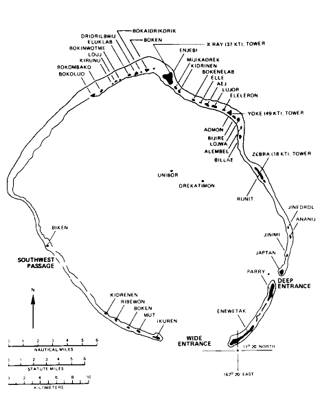
Enewetak Atoll was 30 km wide and 50 km long and comprised about 47 coral islands strung along the reef. The reef enclosing the 1020 square km lagoon was broken in two places by deepwater passages. Enewetak Island, the largest at Enewetak Atoll, lay on the southeastern edge and was only 4 km long and 1 km wide. 36 km away on the northern edge lay Engebi which featured a 2475 foot airstrip used by both the Japanese and the U.S. during the war. Northeast of Enewetak island was Parry Island which had been a U.S. seaplane and supply base.
Bikini Atoll, also known as Eschholtz Atoll, is an oval about 39 km by 23 km long with only one naviagable passage into its lagoon. It comprises 26 islands with a total land area of only 6 square km, surrounding a 600 square km lagoon.
No point at any of the islands was more than 3.5 meters above sea level. The AEC assigned code names to the various islands in the two atolls. At Enewetak they were assigned in two groups - feminine names in alphabetical order starting from the northwest corner and continuing clockwise, and masculine names from the eastern side to the western side. At Bikini the islands were named using the U.S. military phonetic alphabet in use in 1946, starting at the northwest corner and continuing clockwise in sequence.
On 21 October 1986 the Marshall Islands became an independent country (from the US-administered UN trusteeship), although it maintains the status of an associated free state with the U.S. through the Compact of Free Association. Good information sites about the Marshall Islands, and the consequences of testing can be found at: